Overview
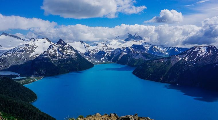
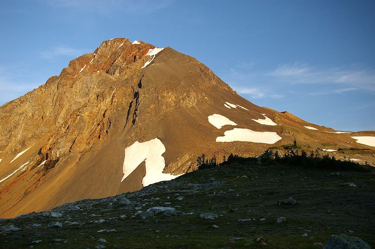
Black Tusk is the jagged black spire you can see from Whistler and from much of Garibaldi Provincial Park. The hike climbs through forest and meadows to the Black Tusk viewpoint, with long views over Garibaldi Lake along the way.
BC Parks states that climbing Black Tusk itself is not recommended due to difficult navigation, fall hazard and loose rocks, and that the trail is not maintained beyond the Black Tusk viewpoint kiosk. This guide covers the hike to the viewpoint.
Getting there
Daisy Lake Road
From Highway 99, a 2 km paved road (Daisy Lake Road) leads to the Rubble Creek parking lot. In winter BC Parks recommends a 4x4 with high clearance, winter tires and chains.
Day-use pass
BC Parks requires free vehicle day-use passes during summer at Rubble Creek. Book at reserve.bcparks.ca/dayuse and check current dates.
Parking
BC Parks: parking is not permitted near the Daisy Lake hydro dam access or anywhere blocking snow-plow access.
The route, segment by segment
Distances and gains below are BC Parks' estimates for the route via Taylor Meadows. BC Parks notes that elevation figures reflect the maximum gain or loss for each section.
- 1
Rubble Creek to the Taylor Meadows junction
6 km770 m gainSteep- Please follow the main trail and do not shortcut: shortcutting damages the environment and can kick debris down the slope onto other hikers.
- Pit toilet near the junction.
- 2
Junction to Taylor Meadows campground
1.5 km180 m gain- Moderate, well-defined trail.
- 3
Taylor Meadows to Black Tusk Junction
2 km180 m gain- Pit toilet at Black Tusk Junction.
- 4
Black Tusk Junction to the viewpoint
4.4 km300 m gainVery steep- BC Parks rates this section difficult, very steep and not maintained beyond the viewpoint kiosk.
- Follow the main trail and avoid braiding.
Rules & safety
No dogs, drones or fires
BC Parks prohibits motorized vehicles, domestic animals, fires and drones in the park year-round.
Do not climb the Tusk
BC Parks: climbing Black Tusk is not recommended due to difficult navigation, fall hazard and loose rocks.
Weather
BC Parks warns the weather can be severe and unforgiving, and day visitors should be capable of camping overnight in case of injury or extreme weather.
Pack it out
Garbage removal is not available. Pack out all garbage.
Camping
All camping requires a permit and a reservation, year-round, at camping.bcparks.ca.
Below the Barrier
BC Parks says the area below the Barrier is a civil defence zone: do not stop or linger there.
When to go
BC Parks says free day-use passes are required during summer months at Rubble Creek. In recent years the pass window ran from mid-June to mid-October (June 13 to October 13 in 2025). Check the current dates and the snow conditions on the upper trail.
Late July to September
The usual window for snow-free trail. This is an estimate: snow on the upper trail varies by year.
June and October
Possible snow, short days and changeable weather. Check conditions.
Questions
How long is the Black Tusk hike?
By BC Parks' segment figures the route via Taylor Meadows is about 13.9 km one way, around 28 km return, with roughly 1,430 m of gain. Other guides report 27 to 29 km and 1,600 to 1,750 m of total climbing, because they count ups and downs.
Do I need a day-use pass?
BC Parks requires free vehicle day-use passes at Rubble Creek during summer months. You don't need one with a valid overnight camping reservation. Book at reserve.bcparks.ca/dayuse and check the current dates.
Can I climb Black Tusk?
BC Parks says climbing the Tusk is not recommended due to difficult navigation, fall hazard and loose rocks, and the trail is not maintained beyond the viewpoint kiosk.
Can I bring my dog?
No. BC Parks prohibits domestic animals in Garibaldi Provincial Park, except accredited assistance dogs.
Safety checklist
Tell someone your plan
Leave your route, group size and expected return time with someone you trust, and check in when you are back. BC AdventureSmart (adventuresmart.ca) has a free trip-plan form.
Check conditions the same day
Look at the weather, road and trail conditions, closures and (in snow season) the avalanche forecast on the day you go, not last week. Use the land manager's page for this guide.
Set a turnaround time
Pick a time to turn back whatever happens, start early, and carry a headlamp. Most trips go wrong in the last hours of the day.
Carry the essentials
Water, food, navigation (map and offline GPS), light, first aid, extra layers, sun protection, a whistle and fire or shelter. A phone alone is not a plan.
Emergencies
Call 911. Cell coverage is unreliable or absent in much of the Sea to Sky backcountry, so consider a satellite messenger and know your location.
Water and wildlife
Wear a life jacket on the water: cold water can disable you in minutes. Carry bear spray where bears are present, keep food secured and give wildlife space.
Sources & disclaimer
This guide draws on BC Parks: Garibaldi Provincial Park Trail Information (updated May 19, 2026); BC Parks: Garibaldi Park.
Last checked November 18, 2026. Figures marked ≈ are approximate, and sources sometimes disagree. Always confirm with the land manager before you go.
Outdoor recreation involves risk, including serious injury and death. This guide is general information compiled from the public sources listed above and was last checked on November 18, 2026. Conditions, access, closures, fees and rules change, and some figures differ between sources. It is not a substitute for current information from the land manager, for proper skills, equipment and preparation, or for your own judgment. You are responsible for your own safety and decisions. To the extent permitted by law, Sea to Sky Trails and its authors accept no liability for loss, injury or damage arising from use of this guide.